June 2, 2007
Last updated: 6/4/07 8:00pm PT
Ozette, Cape Alava, Sand Point, WA 2007
We were sitting around thinking that we needed to see more of the area which we call home. We moved to Seattle from Chicago for more than just an abundance of software companies providing employment. We moved out here for the weather and the scenery. It’s time we took in more of that scenery. So instead of waiting and using vacation time, we decided we would take some short one, maybe two day trips to see some of the nature, and perhaps non-nature, sights near our home. Someday we will be old (OK, older) or maybe we’ll move away from Seattle (can’t imagine why), so there’s no time like the present to enjoy life.
So (hopefully) this will be the first of a series of pages on the local sights. Local doesn’t necessarily mean Washington. It includes Oregon, Idaho, BC, anywhere really. I figure it will take a while to go through all the sights in our state and its neighbors before we expand our radius (plus travel time needs to be considered). The plan is to do something once a month. Some may be exciting, some may be things that every local should do. We still haven’t gone to the top of the Space Needle (but I’m pretty sure that’s not a requirement of residency). I lived in Chicago for 37 years and never made it to the top of the Sears Tower. And because I know you’re bored and need something to read, this will get me to update the website more than once a year. We’ll see how long this lasts.
First up, the end of the Earth. There are a few places that lay claim to being the “western most” point in the lower 48 states. Cape Alava makes that claim, along with Cape Blanco in Oregon. I think the dispute is whether or not the measurement takes place at high or low tide. Then there’s the most “northwestern” point, (notice the “north” in front of the “west”) which is Cape Flattery, WA. This month’s trip was to Cape Alava. We plan on hitting the other two points later this year.
To get to Cape Alava, you have to hike about 3 miles from Ozette, WA. To get to Ozette, you drive about 3.5 hours from the Kingston ferry terminal. Since I like looking at nature but not touching too much of it, we “camped” at the Ramada in Sequim (the ‘e’ is silent). Starting the day in Sequim gave us a head start so we could hike the coast before high tide. The hike is a 9 mile triangle (see maps). Starting at the Ozette ranger station, you hike a little over 3 miles almost straight west to the Pacific Ocean. Then you hike 3 miles south down the beach. Then you hike a little over 3 miles on a northeasterly trail, back to the ranger station. It took us 5 hours to go round trip, and that include a break for lunch.
The first leg of our trip took about 1.5 hours. Most of the path is a raised boardwalk, so you will leave little impact on nature. There seemed to be a lot of ups and downs on this leg of the trail. And since it’s a boardwalk instead of just dirt, it’s a lot of stairs to climb. We first saw the ocean after about an hour and fifteen minutes, but it took us a while to get past the deer. We didn’t want to bother it. But it didn’t really care that we were there. I’m guessing I was about 5 or 6 feet away for the second picture below. There was plenty of grass and he was willing to share.


 The first glimpse of the Pacific Ocean
 It was very foggy, so the view wasn’t so good. You can barely see the base of Ozette Island
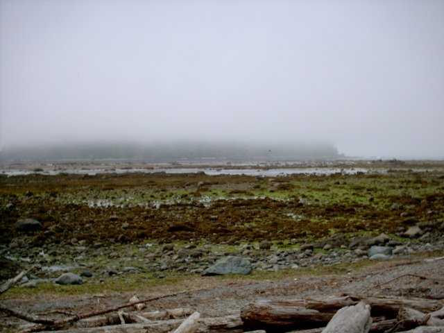 Hiking down the beach was more of a challenge. It took 2 hours to hike the 3 miles from Cape Alava to Sand Point. The first half of the beach was mostly rocks, bigger rocks, so you had to watch your steps so you didn’t twist your ankle or step in a puddle with some crabs or other sea life. Where there was sand, or pebbles, it was difficult walking because you sunk into the ground.

 The second, southern half of the hike was better. The sand was more compacted.


 Here’s a crab, hard to see so I circled him. It the darker spot in the circle, up against the rock.
 When you hike on a trail, if a tree falls, someone cuts it out of the way. On the beach, trees stay where they are. The forest comes right up to the beach, so if a big tree falls into the Pacific, you need to either go over it, under it or around it. When the tide is in, you might get a little wet if you try to go around it. Going around on the forest side is hard because of the steep climb up the hill. So depending on the number of branches touching the ground and how high the trunk is off the ground, you either climb over or duck under. The one pictured below was a combination of over and under.
 About a mile south of Cape Alava, there are some petroglyphs. Don’t bother hiking out here to see them. It looked like some drunk high school kid did these back in the ’70s.
Don’t trip over the dead sea lion! We saw two of these. I’m not posting the picture of the first one we saw as it was pretty gross. (Yeah, I took a picture of the gross one). At Sand Point, the location of the trail head back to Ozette, there’s a sea stack that one hiker we talked to recommended we climb. We got there and really thought about skipping it. It has to be 40 feet high and very steep, no stairs. But we climbed it and boy was it worth it. The view was awesome. Here’s a panorama that I pieced together from the top of the sea stack. The land came to a point, hence the name Sand Point. (yup, still foggy)
 The Sand Point sea stack is behind Denise, and we were pretty far away.
 I hereby claim this to be Hovorka Island. I immediately put it up for sale for 1 million dollars. Oceanfront property, under water only twice a day.
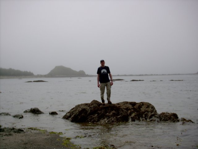 Here’s one that probably never goes under water. (that’s me out there…)
 The 3 mile hike back to Ozette seemed much more level, sure there was still some ups and downs, but seemed less than on the way out, which was good because had hiked 6 miles so far and had 3 more to go.
Just a short swim to Canada across the Strait of Juan de Fuca. (Picture from the drive home)